Travel Corner
Issue 63. Vol 1- (JANUARY 2021)
Longing to escape the bustling city life and disconnect from your ever present computer screen? Taking a breath of fresh air and serenity while exploring Oman’s rugged mountains on foot might be just the perfect getaway.
The towering mighty peaks of spectacular Al Hajar mountains, scarred by a web of endless steep valleys with vertiginous drops, can satisfy both casual and hardcore hikers looking for anything from easy warmup walks to demanding exposed treks spread over several days.
The imposing mountain range stretches for more than 600 kilometres, rising sharply from the so-called Fjords of Arabia in northern Musandam Peninsula to wind along the Omani coastline as a massive impregnable wall with its highest peak, Jebel Shams, topping 3,000 metres.
With many peaks over 2,000metres, its relaxing solitude combined with the breathtaking scenery of dramatic canyons and rolling high altitude plateaus is accessible allyear round as the high altitude offers a refreshing reprieve even when lowlands are suffering from the scorching summer heat.
When to go
The trekking season usually starts in September and ends in May, although if you want to feel the typical winter chill, October to April is a better choice.
During the day, winter mountain temperatures can range from 15 to 25 degrees Celsius. Beware that they can fall to below freezing at night, so a warm sleeping bag and clothes are a must when you are camping.
While rising a bit lower, some 850 metres on average, the Dhofar mountains near the southern port city of Salalah offer different trekking options over the range’s rolling plateaus and deep wadis.
Unlike mostly barren Hajars, their southern slopes are covered with dense woods, which thrive on the annual rainy monsoon season (or khareef in Arabic) from June to September.
Plentiful rain dresses the hills in buoyant greenery, offering an unlikely summer escape to a unique scenery from the heat-tortured rest of Arabian Peninsula.
Many winding trails in the Omani high country used to serve as donkey paths connecting remote mountain villages, where the tough life has not changed much over centuries.
While many routes have been marked by yellow, white and red paint stripes, carrying a good trekking map, compass and GPS is advisable as the weather can change quickly and unpredictably in the mountains.
Abandoned village trek
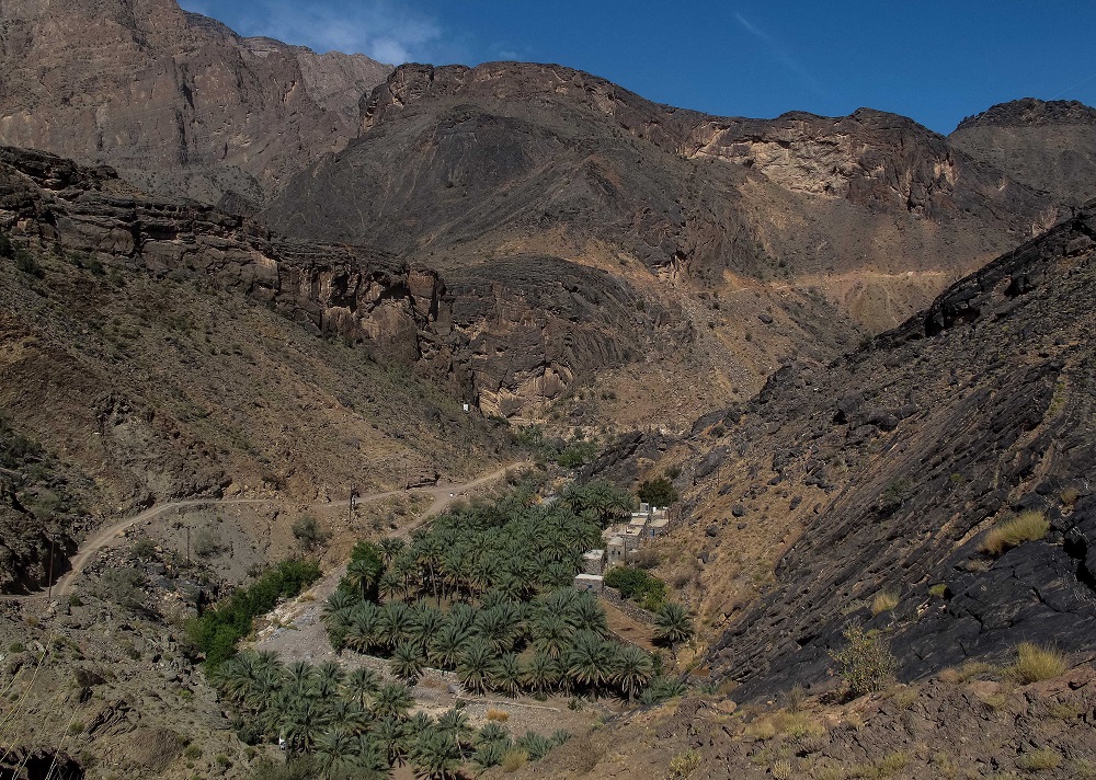
An ancient donkey path, which follows the west flank of the spectacular An Nakhur Gorge, dubbed the Grand Canyon of Oman for its resemblance to its impressive American cousin, will lead you to the abandoned little village of As Sab.
The trek marked as W6 will guide you from the car park before the village of Al Khitaym at 1,900 metres, on an easy going, though partly exposed path along the side wall of the vertiginous canyon to the village of old stone houses, which used to be home to about 15 families.
For those with climbing experience and proper safety gear, a via ferrata – a climbing route with a fixed safety wire – is an option leading up to the plateau from a little lake.
The roundtrip to As Sab, which offers some shade in the afternoon, takes up to three hours.
Jebel Shams challenge
In the same area, a much more ambitious and longer mountain trek marked W4 will challenge your stamina, but reward you with a breathtaking view from the roof of Oman.
Starting at the plateau with the W4 information sign, the rocky and partly steep path follows the rim of the Saydran Gorge, a side wadi of the ‘Grand Canyon’, to a col at 2,700 metres.
From here, the trail levels to reach the southern summit of Jebel Shams at an altitude of 2,997 metres, the highest trekking point in Oman with spectacular vista.
The altitude difference is a demanding 1,000 metres, meaning that the ascent can take up to six hours with a light backpack and an hour more carrying your camping gear. Count with another five and half hours for your descent.
Green mountain rose walk
If you are looking for an easy going, pleasant walk through Jebel Akhdar mountain villages and spectacular terraced gardens with groves of fruit trees such as apricot, peach, and pomegranate, this high altitude walk across the fertile Sayq Plateau is just for you.
Marked W18b, this easy two-hour trek starts in the village of Al Aqur, following old paths along ancient falaj irrigation systems and amazing views over Wadi Muhaydin.
Do not forget to look out for a fossilised coral on the way, and check an ancient rose distillery in the village of Sayq. April is the best time to visit as pale pink damask roses are in full bloom.
Mountains-to-coast traverse
In Eastern Hajars, a very long 28-kilometre mountain trek makes a classic two-day traverse from refreshing emerald water pools of a lush palmgrove-shaded oasis of Bani Khalid to the coastal town of Tiwi.
The rocky and partly steep ancient donkey trail will steal your breath away with beautiful sunrises and sunsets over green wadis and dramatic canyons from the highest point of over 2,000 metres.
The whole trek can be completed in up to 18 hours when loaded with the camping gear with the altitude difference of 1,800 metres.
Old Muscat trail
Even with no time for a two-hour drive into the heart of Hajars, their craggy peaks on the outskirts of Muscat stand ready for a good exercise.
Marked C38, this short hill and wadi walk from the Riyam parking area to Mutrah partly follows an old overland route to Muscat and offers beautiful views over the sea and coastline.
The partly steep but easy trek can take up to two hours one way. A series of stone slabs placed up the hill used to help visitors from the interior reach gates of Muscat in the olden days.